
 The project was conducted in the Kilimanjaro area on the Kenyan side, Chyulu hills, Lake Jipe, Lake Chala and the major springs. The objective of this project was to conduct water resources assessment to quantify water in the project area, understand the groundwater flow with respect to the surface water interaction, determine recharge zones for purposes of conservation and protection and establish the relationship between surface and groundwater resources in the Mt. Kilimanjaro, Lakes Jipe/Challa, Mzima and Chyulu Hills Ecosystems. Isotope hydrology is a nuclear technique that uses both stable and radioactive environmental isotopes to trace the movements of water in the hydrological cycle. It can be utilized to determine areas of recharge, age and residence time of water, origin/source of water, pollution/contaminant sources. It is a technique which can help to improve water resources management and in this case groundwater resources through conservation and protection of recharge areas, applying pollution mitigation measures in areas discovered to be sources of pollution, improved groundwater development and governance.
Evaluation of Surface and Groundwater Interaction of the Kilimanjaro Aquifer Applying Isotope Techniques
Timau Catchment Water Resources Assessment
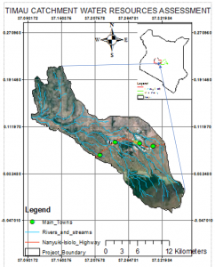 This project was executed in response to the community concern on intensified greenhouse farming in the upstream catchment and rapid development of boreholes affecting the base flows in the middle and downstream areas. The catchment covers about 290 km2 and classified as Arid and Semi-Arid Land (ASAL) therefore, experiences highly variable and unreliable rainfall amounts with up to 2000mm in the highlands and as low as 400-800mm in the lowlands. The aim of the project was to establish the relationship between groundwater and surface water hence put in place measures that will ensure water availability to all through better development of water resources and improve catchment management practices.
This project incorporated geophysical, hydrogeological, hydro-chemical and hydrological investigations so as to determine the influence of groundwater on baseflows. Baseflows can be defined as the least amount of water available in a stream or river during a dry period.